• Welcome
  • Public Protection
  • Healing & Wellness
  • Land & Environment
  • Community
  • Good Governance
COUNTY 2018-19 ANNUAL REPORT
Picture

County Fire Department Enhances the Lives of SLO County Residents in 2018-19

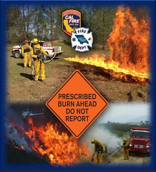
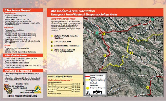
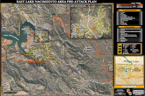
​​CAL FIRE / San Luis Obispo County Fire Department enhanced the lives of SLO County residents in fiscal year 2018-19 by expanding the scope of Emergency Medical Services (EMS), providing new Emergency Medical Technician (EMT) elective skills trainings, using a new electronic health record system, reducing potential fire fuel, and creating pre-attack maps.
Picture
EXPANDING THE SCOPE OF EMS 
 
A well-qualified EMT uses critical thinking and problem-solving skills every day. It is vital that they stay abreast of current methods for improving their proficiency and patient care skills to deal with different scenarios that they may encounter.

EMT Elective Skills. County Fire in Cooperation with the San Luis Obispo EMS Agency brought new EMT skills to San Luis Obispo County. County Fire trained about 215 County Firefighter/EMT's to provide a new standard of care.

​They were trained to:
  • Use Epinephrine auto-injectors to treat anaphylaxis (severe and potentially life-threatening allergic reaction)
  • Administer intra-nasal Narcan for the treatment of opioid overdose
  • Use CPAP (Continuous Positive Airway Pressure) for the treatment of respiratory distress
  • Treat diabetic emergencies through blood glucose monitoring
These new skills will allow our Firefighter/EMT's to provide lifesaving interventions that previously required waiting for the arrival of a paramedic.

ImageTrend Elite. County Fire implemented a new electronic health record system called ImageTrend Elite. This system was deployed to every fire department in San Luis Obispo County.

ImageTrend's Electronic Patient Care Report (ePCR) solution is cloud-based and connected for better data flow. It allows import of data from Computer-Aided Dispatch (CAD) systems and prior patient contacts to speed documentation, facilitate patient tracking, and can send ePCRs electronically to other care providers at scene and the receiving emergency department. This enhances the ability of first responders and hospital staff to quickly provide appropriate patient care in an emergency.

Picture
MAKING THE COUNTY MORE FIRE SAFE
 
California experienced its most destructive and deadliest fires in 2018.  Statewide there were 1.8 million acres burned, 23,000 structures destroyed, 98 civilian lives lost and 6 firefighter deaths.  In San Luis Obispo County, we had 218 wildfires totaling 3,115 acres burned, 60 structure fires and 65 vehicle fires.  The loss of structures and vehicles totaled $4 million. Prevention continues to be a priority. 

Fuel Reductions. The County works to prevent fires in many ways, including prescribed burning (broadcast burning), to burn off excess brush that might otherwise fuel a wildfire.

@FireSafeSLO crews continue removing French broom and chipping dead trees along Cambria Pines Road. #CambriaFireSafe pic.twitter.com/wykN3KHHAH

— CAL FIRE SLO (@CALFIRE_SLO) August 5, 2019
Picture
In 2018, we spent 4,972 personnel hours completing 1,230 acres of broadcast burning and 189 acres of mechanical fuel reduction of hazardous fuels. Broadcast burns are controlled application of fire to fuels, under specified environmental conditions that allow fire to be confined to a predetermined area and produces the fire behavior and characteristics required to attain planned fire treatment and resource management objectives.
 
CAL FIRE / San Luis Obispo County Fire conducts broadcast burns to reduce hazardous fuels and improve forest health.  In our ongoing prevention efforts, we are focused on dramatically increasing broadcast burning; hoping to burn 2,000 to 4,000 acres in 2019.  We now have a dedicated crew for San Luis Obispo County that will focus on high priority hazard reduction and will not be reassigned to fires in other parts of the state.  Strict criteria must be met for a broadcast burn to occur, including smoke dispersal, weather, staffing and fuel moistures.  Many agencies can be involved in broadcast burns.  Here in San Luis Obispo County we collaborate with:

  • Air Pollution Control District (APCD)
  • San Luis Obispo County Planning & Building Department
  • California Department of Fish & Wildlife (CDFW) 
  • Regional Water Quality Control Board (RWQCB)
  • California Coastal Commission (CCC)
  • The California Coastal Act (CCA)
  • California Department of Transportation (Caltrans)
  • US Fish and Wildlife Services (USFWS)
 
CAL FIRE / San Luis Obispo County Fire with private landowners, cooperating agencies, and the County, administer numerous programs which support the California Strategic Fire Plan. In the effort to make the vegetation management achievable, this plan has broken Vegetation Management into three strategic categories: defensible space fuel treatment, non-defensible space fuel treatment, and vegetative management prescriptions.

Within the last year, County Fire has:
  • Burned 1,230 acres in planned, prescribed burns
  • Reviewed 831 fire plans
  • Inspected 8,496 properties for defensible space
 
Environmental review must be conducted for all pre-fire management activities that could cause either direct or indirect changes to the natural or human environment. Fuels treatment efforts conducted by County Fire include the following methods and techniques:

Methods
Techniques
  • Defensible Space Treatment
  • Non – Defensible Space Treatment
         Fuel Breaks
         Fire Breaks
         Prescribed Burning
         Hazard Reduction
         Range Improvement
         Training Burns
         Invasive Weed Control
  • Ingress/Egress Enhancement
         Roads
         Truck Trails
  • Mechanical
         Mowing
         Mastication
         Piling/Crushing
         Plowing/Disking/Harrowing
  • Manual/Hand Work
         Cut/Lop/Scatter
         Cut/Pile/Burn
         Cut/Chip
         Pruning
         Weed eating
  • Broadcast Burning
  • Prescribed Herbivory 
         Cattle
         Goats
  • Chemical Applications
Widland Pre-Attack maps.  County Fire created five additional wildland pre-attack maps, which cover several high-fire hazard areas in the County. Quality maps are critical to effectively manage incidents within San Luis Obispo County.

​These five new maps were made possible with funding from the San Luis Obispo County Community Fire Safe Council. CAL FIRE Pre-Fire Engineering/GIS created the Wildland Pre-Attack maps to add to their existing 10 maps which aid first responders in planning and fighting wildland fires in San Luis Obispo County.
 
We are taking steps toward creating wildland pre-attack maps that cover all high fire hazard areas in the county.  Pre-fire management is a collective term that refers to all activities undertaken by county land managers, property owners, agencies and fire departments intended to reduce the risk of wildfire and resulting suppression costs and to minimize the resulting damage to lives, property, and the environment.
Picture
​In the last decade, geographic techniques have increased and been broadly applied to the fire service. Geographic Information Systems (GIS) have become a major tool for the fire service to improve preparedness, response and recovery to incidents. Quality spatial information is critical to effectively manage an incident where large numbers of public safety resources are deployed with various assignments. GIS techniques have made access to maps and imagery commonplace.
 
One side of these plans include text with specific information about the geographic area with regards to climate, topology, fuel types, demographics etc., as well as specific hazards, additional/specialized resource recommendations, and general strategies and tactics.  The other side is a road map with key tactical locations represented, including escape routes, safety zones, radio frequency availability and lookouts (LCES) as well as items such as proposed dozer line, safe refuge areas, staging areas, helispots etc. 
 
Moving into next fiscal year, the County Fire team will continue to work with the community and partnering agencies to protect lives, property and the environment from fire hazards. 
Picture
< Best in Nation
Fighting High-Tech Crime >
Picture
Download This Report
Download and print a complete copy of the 2018-19 Annual Report. 


Other Related Reports
Comprehensive Financial Reports
FY 2018-19 Year-End Financial Status Report​ (PDF)
FY 2018-19 Performance Measures Results (PDF)

2018 Annual Crop Report (PDF)
2018 Commission on the Status of Women Annual Report (PDF)
​2019 Homeless Census & Survey Report (PDF)
2019 Legislative Platform (PDF)

Prior County Annual Reports
Affordable Housing Annual Report  (PDF)
​Business Migration Report (PDF)
County Business Improvement District Year-End Report (PDF)
Mental Health Services Act Annual Update (PDF)​
​Special Districts Fire Protection Study (PDF)

2017-18 Tourism Marketing District Annual Report (PDF)

Annual Report Sitemap
Home Page: Ideas Into Action
Public Protection
​Best in Nation
Fire Safe County
Fighting High-Tech Crimes
Message from Sheriff
New Emergency Website
Supervising Sex Offenders 
Your Children, Our Priority
Healing & Wellness
Expanding Crisis Services
Helping Veterans in Jail
Improving Public Health
Meeting Basic Needs
​Rescuing Horses
Land
Agriculture, Weights & Measures
Energy Efficiency
Roads, Water & Public Works
Community
100 Years of Libraries
Impacting Local Economy
Parks & Recreation Costs
Training Master Gardeners
Governance
Diablo Canyon Closure
Digitizing Property Records
Elections & Records
Labor Bargaining
Modern Tax Processing
Saving with New Systems
Taking a Regional Approach
Year-End Financial Status Report

Copyright 2019 County of San Luis Obispo | All Rights Reserved
  • Welcome
  • Public Protection
  • Healing & Wellness
  • Land & Environment
  • Community
  • Good Governance